
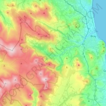
The Municipal District of Bray topographic map
Interactive map
Click on the map to display elevation.
About this map
Name: The Municipal District of Bray topographic map, elevation, terrain.
Average elevation: 283 m
Minimum elevation: 0 m
Maximum elevation: 747 m
Other topographic maps
Click on a map to view its topography, its elevation and its terrain.
The Municipal District of Greystones
The Municipal District of Greystones, County Wicklow, Leinster, Ireland
Average elevation: 89 m
Blessington
Blessington, County Wicklow, Leinster, Ireland
Average elevation: 205 m
Donard
Ireland > County Wicklow > Donard
Donard, The Municipal District of Baltinglass, County Wicklow, Leinster, W91 TW42, Ireland
Average elevation: 218 m