Geolocate

Walnut topographic map

Click on the map to display elevation.

About this map

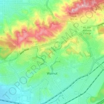
Name: Walnut topographic map, elevation, terrain.

Location: Walnut, Los Angeles County, California, United States (34.00268 -117.89572 34.06240 -117.82469)

Average elevation: 221 m

Minimum elevation: 128 m

Maximum elevation: 403 m

Gear up for your next adventure:

🧥Softshell Jackets - Flexible outdoor jackets
Outdoor Coffee Makers - Enjoy quality coffee at the summit of your favorite peak
🦯Adjustable Trekking Poles - Reduce impact on knees when descending steep topographic ridges
🥾Hiking Gaiters - Leg protection for trails
🔌Fast Charging Adapters - Quickly top up all your gear before heading back into the field

As an Amazon Associate, this site earns from qualifying purchases at no extra cost to you.