
Harju topographic map
Interactive map
Click on the map to display elevation.
About this map
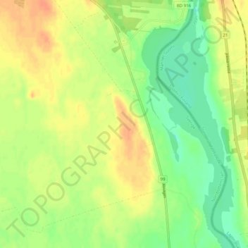
Name: Harju topographic map, elevation, terrain.
Location: Harju, Haparanda kommun, Comté de Norrbotten, 953 93, Suède (66.10814 23.88081 66.14814 23.92081)
Average elevation: 34 m
Minimum elevation: 16 m
Maximum elevation: 50 m
Other topographic maps
Click on a map to view its topography, its elevation and its terrain.
Kiruna kommun
Kiruna kommun, Comté de Norrbotten, Suède
Average elevation: 618 m