
Red Dog Mine topographic map
Interactive map
Click on the map to display elevation.
About this map
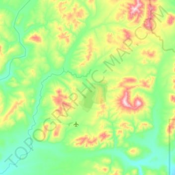
Name: Red Dog Mine topographic map, elevation, terrain.
Location: Red Dog Mine, Northwest Arctic, Alaska, United States (67.97066 -163.05568 68.17014 -162.71868)
Average elevation: 315 m
Minimum elevation: 112 m
Maximum elevation: 923 m
Other topographic maps
Click on a map to view its topography, its elevation and its terrain.
Buckland
United States > Alaska > Northwest Arctic
Buckland, Northwest Arctic, Alaska, 99727, United States
Average elevation: 9 m
Noatak
United States > Alaska > Northwest Arctic
Noatak, Northwest Arctic, Alaska, United States
Average elevation: 31 m
Kotzebue
United States > Alaska > Northwest Arctic
Kotzebue, Northwest Arctic, Alaska, United States
Average elevation: 9 m
Mount Igikpak
United States > Alaska > Northwest Arctic
Mount Igikpak, Northwest Arctic, Alaska, United States
Average elevation: 1,728 m