
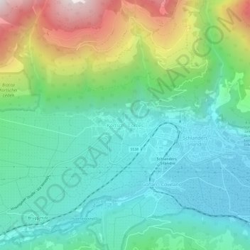
Kortsch - Corzes topographic map
Interactive map
Click on the map to display elevation.
About this map
Name: Kortsch - Corzes topographic map, elevation, terrain.
Average elevation: 1,067 m
Minimum elevation: 678 m
Maximum elevation: 2,051 m
Other topographic maps
Click on a map to view its topography, its elevation and its terrain.
Muls
Italy > Trentino-Alto Adige/Südtirol > South Tyrol > Sarntal - Sarentino
Muls, Sarntal - Sarentino, Salten-Schlern - Salto-Sciliar, South Tyrol, Trentino-Alto Adige/Südtirol, Italy
Average elevation: 1,678 m
Laimburg - Castel Varco
Italy > Trentino-Alto Adige/Südtirol > South Tyrol > Vadena - Pfatten
Laimburg - Castel Varco, LS/SP162, Kreithof - Maso Kreit, Vadena - Pfatten, Überetsch-Unterland - Oltradige-Bassa Atesina, South Tyrol, Trentino-Alto Adige/Südtirol, 39051, Italy
Average elevation: 321 m
Vetzan - Vezzano
Italy > Trentino-Alto Adige/Südtirol > South Tyrol > Schlanders - Silandro
Vetzan - Vezzano, Schlanders - Silandro, Vinschgau - Val Venosta, South Tyrol, Trentino-Alto Adige/Südtirol, 39028, Italy
Average elevation: 978 m
Schlanders - Silandro
Italy > Trentino-Alto Adige/Südtirol > South Tyrol
Schlanders - Silandro, Vinschgau - Val Venosta, South Tyrol, Trentino-Alto Adige/Südtirol, 39028, Italy
Average elevation: 1,912 m
Urtijëi - St. Ulrich in Gröden - Ortisei
Italy > Trentino-Alto Adige/Südtirol > South Tyrol
Urtijëi - St. Ulrich in Gröden - Ortisei, Salten-Schlern - Salto-Sciliar, South Tyrol, Trentino-Alto Adige/Südtirol, 39046, Italy
Average elevation: 1,688 m
Ulten - Ultimo
Italy > Trentino-Alto Adige/Südtirol > South Tyrol
Ulten - Ultimo, Burggrafenamt - Burgraviato, South Tyrol, Trentino-Alto Adige/Südtirol, 39016, Italy
Average elevation: 2,003 m
Bolzano - Bozen
Italy > Trentino-Alto Adige/Südtirol > South Tyrol
Bolzano - Bozen, South Tyrol, Trentino-Alto Adige/Südtirol, 39100, Italy
Average elevation: 716 m