
Jacksonville topographic map
Interactive map
Click on the map to display elevation.
About this map
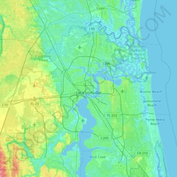
Name: Jacksonville topographic map, elevation, terrain.
Location: Jacksonville, Duval County, Florida, United States (30.10375 -82.04939 30.58621 -81.31671)
Average elevation: 10 m
Minimum elevation: -4 m
Maximum elevation: 65 m
Other topographic maps
Click on a map to view its topography, its elevation and its terrain.
Atlantic Beach
United States > Florida > Duval County
Atlantic Beach, Duval County, Florida, 32233, United States
Average elevation: 2 m
Pineland Gardens
United States > Florida > Duval County > Jacksonville
Pineland Gardens, Jacksonville, Duval County, Florida, 32216, United States
Average elevation: 9 m
Jacksonville
United States > Florida > Duval County > Jacksonville
Jacksonville, Duval County, Florida, 32202, United States
Average elevation: 9 m