Geolocate

Makiling topographic map

Click on the map to display elevation.

About this map

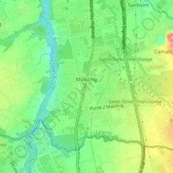
Name: Makiling topographic map, elevation, terrain.

Location: Makiling, Calamba, Laguna, Calabarzon, 4027, Philippines (14.14090 121.12844 14.16539 121.15961)

Average elevation: 136 m

Minimum elevation: 87 m

Maximum elevation: 214 m

Other topographic maps

Click on a map to view its topography, its elevation and its terrain.

Calamba Town Plaza

Philippines > Laguna > Calamba

Average elevation: 11 m

88 Spa & Resort

Philippines > Laguna > Calamba

Average elevation: 83 m

Bucal

Philippines > Laguna > Calamba

Average elevation: 22 m

Bucal Reservoir

Philippines > Laguna > Calamba

Average elevation: 42 m

ASN Ph2 Park

Philippines > Laguna > Calamba

Average elevation: 133 m

Gear up for your next adventure:

🍴Titanium Spork & Cutlery - Indestructible and feather-light eating utensils
🔌Fast Charging Adapters - Quickly top up all your gear before heading back into the field
🧥Thermal Emergency Blankets - Compact Mylar blankets to prevent hypothermia if stranded overnight
🕯️Emergency Whistles - Safety whistles for hiking
🧥Down Jackets - Insulated jackets for cold weather

As an Amazon Associate, this site earns from qualifying purchases at no extra cost to you.