
Kattowitz topographic map
Interactive map
Click on the map to display elevation.
About this map
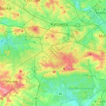
Name: Kattowitz topographic map, elevation, terrain.
Location: Kattowitz, GZM, Woiwodschaft Schlesien, Polen (50.13006 18.89154 50.29769 19.12442)
Average elevation: 275 m
Minimum elevation: 236 m
Maximum elevation: 351 m
Other topographic maps
Click on a map to view its topography, its elevation and its terrain.
Kattowitz
Polen > Woiwodschaft Schlesien > Kattowitz
Kattowitz, Górnośląsko-Zagłębiowska Metropolia, Woiwodschaft Schlesien, Polen
Average elevation: 275 m