
Thank you for supporting this site ❤️
Make a donation
Make a donation
Gear up for your next adventure:
As an Amazon Associate, this site earns from qualifying purchases at no extra cost to you.
Villamagna topographic map
Click on the map to display elevation.
Thank you for supporting this site ❤️
Make a donation
Make a donation
Gear up for your next adventure:
As an Amazon Associate, this site earns from qualifying purchases at no extra cost to you.
About this map
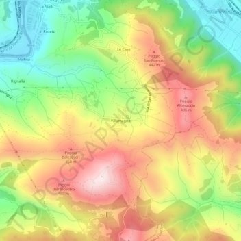
Name: Villamagna topographic map, elevation, terrain.
Location: Villamagna, Bagno a Ripoli, Florence, Tuscany, 50061, Italy (43.74156 11.36243 43.78156 11.40243)
Average elevation: 305 m
Minimum elevation: 57 m
Maximum elevation: 559 m
Thank you for supporting this site ❤️
Make a donation
Make a donation
Gear up for your next adventure:
As an Amazon Associate, this site earns from qualifying purchases at no extra cost to you.