
Make a donation
Gear up for your next adventure:
As an Amazon Associate, this site earns from qualifying purchases at no extra cost to you.
Porto da Cruz topographic map
Click on the map to display elevation.
Make a donation
Gear up for your next adventure:
As an Amazon Associate, this site earns from qualifying purchases at no extra cost to you.
Porto da Cruz
The northern parish is enveloped by the mountains of Paul da Serra: Pico da Suna (1040 metres), Pico do Larano (765 metres) and Pico da Maiata (766 metres) are the highest points in the parish. Even along the coast, Penha de Águia (a mountainous escarpment 580 metres in altitude) is difficult to climb; the area, Penha da Águia, means mountain of the eagles, giving the impression that only the birds settle these lands.
Make a donation
Gear up for your next adventure:
As an Amazon Associate, this site earns from qualifying purchases at no extra cost to you.
About this map
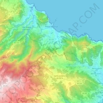
Name: Porto da Cruz topographic map, elevation, terrain.
Location: Porto da Cruz, Machico, Madeira, Portugal (32.70993 -16.90556 32.78754 -16.78922)
Average elevation: 448 m
Minimum elevation: -2 m
Maximum elevation: 1,409 m
Make a donation
Gear up for your next adventure:
As an Amazon Associate, this site earns from qualifying purchases at no extra cost to you.
Other topographic maps
Click on a map to view its topography, its elevation and its terrain.