Geolocate

Luwu topographic map

Click on the map to display elevation.

About this map

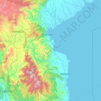
Name: Luwu topographic map, elevation, terrain.

Location: Luwu, Marinding, South Sulawesi, Sulawesi, Indonesia (-3.66741 119.88350 -2.65718 120.42069)

Average elevation: 515 m

Minimum elevation: 0 m

Maximum elevation: 3,414 m

Gear up for your next adventure:

🎒40L Day Hiking Backpacks - Comfortable packs with hydration support for long days exploring topographic peaks
📍Handheld GPS - GPS devices for hiking and navigation
📣High-Decibel Survival Whistles - Signaling tool for rescue that carries much further than a human voice
🦟Heavy Duty Insect Repellent - Essential protection against flies, mozzies, and march flies
🖼️Scratch-off Australia Map - Track the regions and peaks you have explored geographically

As an Amazon Associate, this site earns from qualifying purchases at no extra cost to you.