
Isinlivi topographic map
Interactive map
Click on the map to display elevation.
About this map
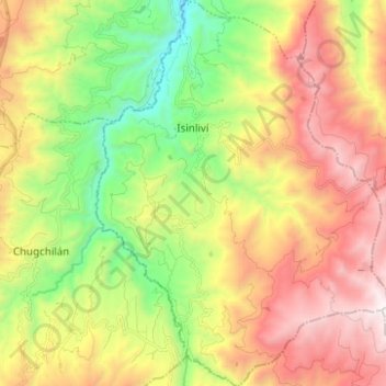
Name: Isinlivi topographic map, elevation, terrain.
Location: Isinlivi, Sigchos, Cotopaxi, Équateur (-0.84258 -78.90123 -0.71792 -78.80661)
Average elevation: 3,376 m
Minimum elevation: 2,498 m
Maximum elevation: 4,282 m
Other topographic maps
Click on a map to view its topography, its elevation and its terrain.
Itupungo Bajo
Équateur > Cotopaxi > Sigchos > Chugchillan
Itupungo Bajo, Chugchillan, Sigchos, Cotopaxi, 050504, Équateur
Average elevation: 3,232 m
Quilotoa
Équateur > Cotopaxi > Sigchos > Chugchillan
Quilotoa, Chugchillan, Sigchos, Cotopaxi, 050456, Équateur
Average elevation: 3,553 m