
Make a donation
Gear up for your next adventure:
As an Amazon Associate, this site earns from qualifying purchases at no extra cost to you.
Ahrenfeld topographic map
Click on the map to display elevation.
Make a donation
Gear up for your next adventure:
As an Amazon Associate, this site earns from qualifying purchases at no extra cost to you.
Ahrenfeld
Ahrenfeld liegt innerhalb des Leineberglands im äußersten Osten des Naturparks Weserbergland Schaumburg-Hameln und ist von den Höhenzügen Osterwald im Norden, Külf im Südosten, Thüster Berg direkt im Süden und Ith etwas im Westen eingerahmt. Nach Norden fällt der Blick auf das Tal des Leine-Zuflusses Saale. Mit der Kansteinhütte, einer Selbstversorgerhütte des Alpenvereins Hannover, ist der Ort Ausgangspunkt für Klettertouren im Thüster Berg. Durch Ahrenfeld führt der Weser-Leine-Radweg.
Make a donation
Gear up for your next adventure:
As an Amazon Associate, this site earns from qualifying purchases at no extra cost to you.
About this map
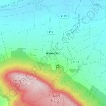
Name: Ahrenfeld topographic map, elevation, terrain.
Average elevation: 191 m
Minimum elevation: 97 m
Maximum elevation: 441 m
Make a donation
Gear up for your next adventure:
As an Amazon Associate, this site earns from qualifying purchases at no extra cost to you.