
Make a donation
Gear up for your next adventure:
As an Amazon Associate, this site earns from qualifying purchases at no extra cost to you.
Tabia Tsaka topographic map
Click on the map to display elevation.
Make a donation
Gear up for your next adventure:
As an Amazon Associate, this site earns from qualifying purchases at no extra cost to you.
Tabia Tsaka
Zabuye Lake is a hypersaline, landlocked soda lake located at an elevation of 4,400 metres (14,400 ft) in the Shigatse Prefecture of Tibet Autonomous Region, 1,050 km (650 mi) from Lhasa. The lake gives its name to the mineral zabuyelite (lithium carbonate, Li2CO3), which was discovered here in 1987 and has been mined since 2004–2005. In 2008, the salt mine at the lake was regarded as the major source of lithium in China.
Make a donation
Gear up for your next adventure:
As an Amazon Associate, this site earns from qualifying purchases at no extra cost to you.
About this map
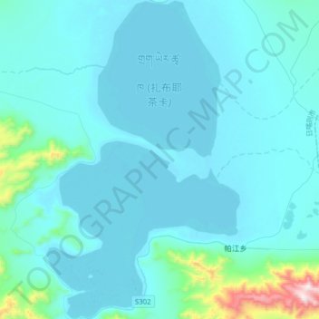
Name: Tabia Tsaka topographic map, elevation, terrain.
Location: Tabia Tsaka, Drongpa County, Shigatse Prefecture, Tibet, China (31.24569 83.94160 31.51068 84.13040)
Average elevation: 4,497 m
Minimum elevation: 4,421 m
Maximum elevation: 5,445 m
Make a donation
Gear up for your next adventure:
As an Amazon Associate, this site earns from qualifying purchases at no extra cost to you.