
Mühlbach topographic map
Interactive map
Click on the map to display elevation.
About this map
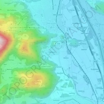
Name: Mühlbach topographic map, elevation, terrain.
Average elevation: 573 m
Minimum elevation: 459 m
Maximum elevation: 1,114 m
Other topographic maps
Click on a map to view its topography, its elevation and its terrain.
Kleiner Traithen
Deutschland > Bayern > Landkreis Rosenheim > Kiefersfelden
Kleiner Traithen, Kiefersfelden, Landkreis Rosenheim, Bayern, 83735, Deutschland
Average elevation: 1,336 m
Au
Deutschland > Bayern > Landkreis Rosenheim > Kiefersfelden > Au
Au, Kiefersfelden, Landkreis Rosenheim, Bayern, 83088, Deutschland
Average elevation: 549 m