
Make a donation
Gear up for your next adventure:
As an Amazon Associate, this site earns from qualifying purchases at no extra cost to you.
Voitsberg topographic map
Click on the map to display elevation.
Make a donation
Gear up for your next adventure:
As an Amazon Associate, this site earns from qualifying purchases at no extra cost to you.
About this map
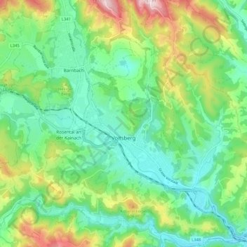
Name: Voitsberg topographic map, elevation, terrain.
Location: Voitsberg, Bezirk Voitsberg, Styria, 8570, Austria (47.01947 15.11350 47.08949 15.21279)
Average elevation: 480 m
Minimum elevation: 365 m
Maximum elevation: 736 m
Make a donation
Gear up for your next adventure:
As an Amazon Associate, this site earns from qualifying purchases at no extra cost to you.
Other topographic maps
Click on a map to view its topography, its elevation and its terrain.
Muggauberg
Austria > Styria > Bezirk Voitsberg > Krottendorf-Gaisfeld > Krottendorf bei Ligist
Average elevation: 417 m
Make a donation
Gear up for your next adventure:
As an Amazon Associate, this site earns from qualifying purchases at no extra cost to you.