
Thank you for supporting this site ❤️
Make a donation
Make a donation
Gear up for your next adventure:
As an Amazon Associate, this site earns from qualifying purchases at no extra cost to you.
Justinhaugh topographic map
Click on the map to display elevation.
Thank you for supporting this site ❤️
Make a donation
Make a donation
Gear up for your next adventure:
As an Amazon Associate, this site earns from qualifying purchases at no extra cost to you.
About this map
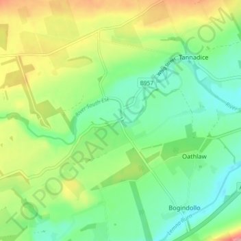
Name: Justinhaugh topographic map, elevation, terrain.
Location: Justinhaugh, Oathlaw, Angus, Scotland, DD8 3SD, United Kingdom (56.68193 -2.90128 56.72193 -2.86128)
Average elevation: 86 m
Minimum elevation: 49 m
Maximum elevation: 151 m
Thank you for supporting this site ❤️
Make a donation
Make a donation
Gear up for your next adventure:
As an Amazon Associate, this site earns from qualifying purchases at no extra cost to you.