
Beckwith topographic map
Interactive map
Click on the map to display elevation.
About this map
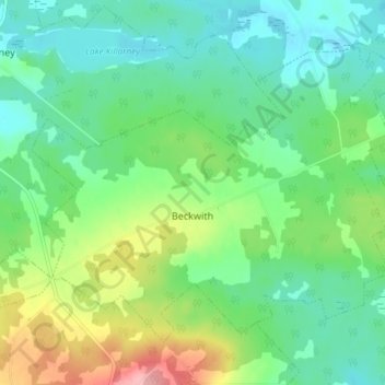
Name: Beckwith topographic map, elevation, terrain.
Average elevation: 44 m
Minimum elevation: 8 m
Maximum elevation: 126 m
Other topographic maps
Click on a map to view its topography, its elevation and its terrain.
West Amherst
Canada > Nova Scotia > Municipality of the County of Cumberland
West Amherst, Municipality of the County of Cumberland, Cumberland County, Nova Scotia, B4H 3Y4, Canada
Average elevation: 13 m
Westchester
Canada > Nova Scotia > Municipality of the County of Cumberland
Westchester, Municipality of the County of Cumberland, Cumberland County, Nova Scotia, Canada
Average elevation: 157 m
Mapleton
Canada > Nova Scotia > Municipality of the County of Cumberland
Mapleton, Municipality of the County of Cumberland, Cumberland County, Nova Scotia, B0M 1W0, Canada
Average elevation: 102 m
Northport
Canada > Nova Scotia > Municipality of the County of Cumberland
Northport, Municipality of the County of Cumberland, Cumberland County, Nova Scotia, B0L 1E0, Canada
Average elevation: 12 m
Maccan
Canada > Nova Scotia > Municipality of the County of Cumberland
Maccan, Municipality of the County of Cumberland, Cumberland County, Nova Scotia, B0L 1B0, Canada
Average elevation: 45 m
Parrsboro
Canada > Nova Scotia > Municipality of the County of Cumberland
Parrsboro, Municipality of the County of Cumberland, Cumberland County, Nova Scotia, B0M 1S0, Canada
Average elevation: 25 m
Gulf Shore
Canada > Nova Scotia > Municipality of the County of Cumberland > Gulf Shore
Gulf Shore, Municipality of the County of Cumberland, Cumberland County, Nova Scotia, B0K 1L0, Canada
Average elevation: 11 m