
Cornish topographic map
Interactive map
Click on the map to display elevation.
About this map
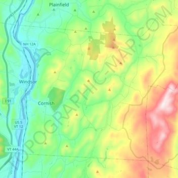
Name: Cornish topographic map, elevation, terrain.
Location: Cornish, Sullivan County, New Hampshire, United States (43.42379 -72.39912 43.52518 -72.22558)
Average elevation: 272 m
Minimum elevation: 83 m
Maximum elevation: 945 m
According to the United States Census Bureau, the town has a total area of 42.6 square miles (110.4 km2), of which 42.0 square miles (108.7 km2) are land and 0.66 square miles (1.7 km2) are water, comprising 1.54% of the town.[1] The Connecticut River forms the western boundary of the town, which is also the New Hampshire–Vermont border. The town is drained by direct tributaries of the Connecticut: Blow-me-down Brook, Mill Brook, and Walker Brook; and by Redwater Brook, which flows south to the Sugar River in Claremont before that river joins the Connecticut.[5] The long ridge of Croydon Mountain follows the eastern boundary of town; the highest point in town is a knob on Croydon Mountain which reaches an elevation of 2,323 ft (708 m) above sea level.[6] The eastern part of the town is a portion of the approximately 25,000-acre (100 km2) Blue Mountain Forest Association private game preserve, also known locally as Corbin Park, named after its founder, Austin Corbin.
Other topographic maps
Click on a map to view its topography, its elevation and its terrain.
Charlestown
United States > New Hampshire > Sullivan County
Charlestown, Sullivan County, New Hampshire, 03603, United States
Average elevation: 256 m