Geolocate

Murchison topographic map

Click on the map to display elevation.

About this map

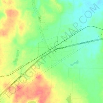
Name: Murchison topographic map, elevation, terrain.

Location: Murchison, Henderson County, Texas, United States (32.25328 -95.78138 32.30348 -95.73683)

Average elevation: 146 m

Minimum elevation: 115 m

Maximum elevation: 183 m

Gear up for your next adventure:

GPS Watches - GPS watches for outdoor sports
Outdoor Coffee Makers - Enjoy quality coffee at the summit of your favorite peak
🛰️Handheld GPS Units - Rugged GPS devices for tracking coordinates and elevation in the Australian bush
🛌Sleeping Mats - Insulated mats for camping comfort
🩹Wilderness First Aid Kits - Comprehensive medical kits tailored for hiking and remote exploration

As an Amazon Associate, this site earns from qualifying purchases at no extra cost to you.