
Make a donation
Gear up for your next adventure:
As an Amazon Associate, this site earns from qualifying purchases at no extra cost to you.
Andermatt topographic map
Click on the map to display elevation.
Make a donation
Gear up for your next adventure:
As an Amazon Associate, this site earns from qualifying purchases at no extra cost to you.
Andermatt
Andermatt (Romansh: Ursera) is a mountain village and municipality in the canton of Uri in Switzerland. At an elevation of 1,437 meters (4,715 ft) above sea level, Andermatt is located at the center of the Saint-Gotthard Massif and the historical center cross of north-south and east-west traverses of Switzerland. It is some 28 km (17 mi) south of Altdorf, the capital of Uri.
Make a donation
Gear up for your next adventure:
As an Amazon Associate, this site earns from qualifying purchases at no extra cost to you.
About this map
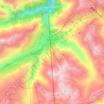
Name: Andermatt topographic map, elevation, terrain.
Location: Andermatt, Korporation Ursern, Uri, 6490, Switzerland (46.56410 8.54654 46.67706 8.68192)
Average elevation: 2,127 m
Minimum elevation: 1,023 m
Maximum elevation: 2,972 m
Make a donation
Gear up for your next adventure:
As an Amazon Associate, this site earns from qualifying purchases at no extra cost to you.
Other topographic maps
Click on a map to view its topography, its elevation and its terrain.