
Bedford topographic map
Interactive map
Click on the map to display elevation.
About this map
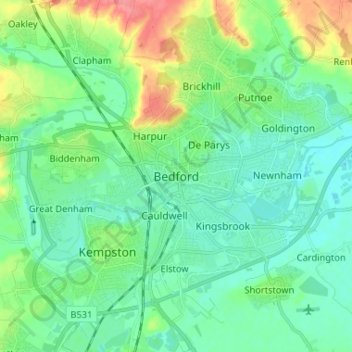
Name: Bedford topographic map, elevation, terrain.
Average elevation: 37 m
Minimum elevation: 20 m
Maximum elevation: 83 m
Other topographic maps
Click on a map to view its topography, its elevation and its terrain.
Westoning
United Kingdom > England > Central Bedfordshire
Westoning, Central Bedfordshire, England, United Kingdom
Average elevation: 86 m
Bedfordshire
United Kingdom > England > Central Bedfordshire
Bedfordshire, Central Bedfordshire, England, United Kingdom
Average elevation: 81 m
Broom
United Kingdom > England > Central Bedfordshire
Broom, Central Bedfordshire, England, SG18 9NN, United Kingdom
Average elevation: 37 m
Southill
United Kingdom > England > Central Bedfordshire
Southill, Central Bedfordshire, England, United Kingdom
Average elevation: 50 m
Biggleswade
United Kingdom > England > Central Bedfordshire
Biggleswade, Central Bedfordshire, England, United Kingdom
Average elevation: 37 m