
Thank you for supporting this site ❤️
Make a donation
Make a donation
Gear up for your next adventure:
As an Amazon Associate, this site earns from qualifying purchases at no extra cost to you.
Tittmoning topographic map
Click on the map to display elevation.
Thank you for supporting this site ❤️
Make a donation
Make a donation
Gear up for your next adventure:
As an Amazon Associate, this site earns from qualifying purchases at no extra cost to you.
About this map
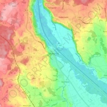
Name: Tittmoning topographic map, elevation, terrain.
Location: Tittmoning, Landkreis Traunstein, Bavaria, 84529, Germany (48.02217 12.72765 48.10217 12.80765)
Average elevation: 433 m
Minimum elevation: 357 m
Maximum elevation: 526 m
Thank you for supporting this site ❤️
Make a donation
Make a donation
Gear up for your next adventure:
As an Amazon Associate, this site earns from qualifying purchases at no extra cost to you.