
Levi Ski Resort topographic map
Interactive map
Click on the map to display elevation.
About this map
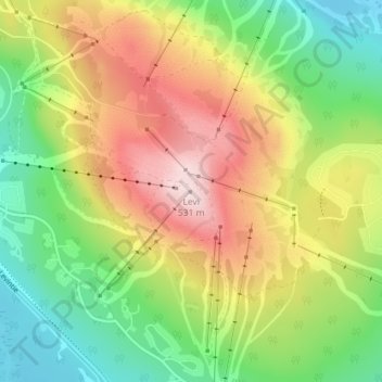
Name: Levi Ski Resort topographic map, elevation, terrain.
Average elevation: 338 m
Minimum elevation: 191 m
Maximum elevation: 528 m
Other topographic maps
Click on a map to view its topography, its elevation and its terrain.
Kittilä
The ski resort Levi is situated in the village of Sirkka, Kittilä on Levi Fell (in Finnish "Levitunturi") (elevation 531 metres (1742 feet)). The resort hosts a slalom event early each season on the Alpine World Cup circuit and offers both downhill and cross-country skiing to the public, as well as snow…
Average elevation: 254 m