
Docking topographic map
Click on the map to display elevation.
Docking
Docking village in the centre of the parish is situated at an elevation of 82.7 metres (272 feet), which makes it one of the highest in Norfolk. It is surrounded by arable farmland having little woodland and is a nucleated settlement, with only one historical hamlet associated with it. This is Summerfield to the north-west, the site of a separate medieval village. The two modern hamlets in the parish are Burntstalk to the west around the former workhouse, and Docking Common to the south-east which postdates the enclosure of the village common in 1859.
About this map
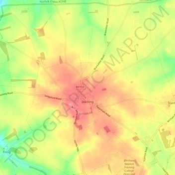
Name: Docking topographic map, elevation, terrain.
Average elevation: 63 m
Minimum elevation: 20 m
Maximum elevation: 94 m
Other topographic maps
Click on a map to view its topography, its elevation and its terrain.
St John's Fen End
United Kingdom > England > Norfolk > King's Lynn and West Norfolk
Average elevation: 1 m
Brandon Bank
United Kingdom > England > Norfolk > King's Lynn and West Norfolk > Feltwell
Average elevation: -1 m
Castle Rising
United Kingdom > England > Norfolk > King's Lynn and West Norfolk > Castle Rising
Average elevation: 22 m
Great Bircham
United Kingdom > England > Norfolk > King's Lynn and West Norfolk
Average elevation: 61 m
Bircham Tofts
United Kingdom > England > Norfolk > King's Lynn and West Norfolk > Great Bircham
Average elevation: 63 m
Brancaster Staithe
United Kingdom > England > Norfolk > King's Lynn and West Norfolk
Average elevation: 18 m
Methwold Hythe
United Kingdom > England > Norfolk > King's Lynn and West Norfolk > Methwold
Average elevation: 8 m
Flaxley
United Kingdom > England > Norfolk > King's Lynn and West Norfolk > Holme next the Sea
Average elevation: 8 m
Old Hunstanton Lighthouse
United Kingdom > England > Norfolk > King's Lynn and West Norfolk > Hunstanton > Old Hunstanton
Average elevation: 9 m
Walpole St Andrew
United Kingdom > England > Norfolk > King's Lynn and West Norfolk
Average elevation: 3 m
Ely-Ouse-Essex Water Transfer Scheme
United Kingdom > England > Norfolk > King's Lynn and West Norfolk > Hockwold cum Wilton
Average elevation: 4 m
St John's Highway
United Kingdom > England > Norfolk > King's Lynn and West Norfolk
Average elevation: 2 m
Sandringham Estate
United Kingdom > England > Norfolk > King's Lynn and West Norfolk > Sandringham
Average elevation: 25 m
Walton Highway
United Kingdom > England > Norfolk > King's Lynn and West Norfolk
Average elevation: 3 m
Pur Fleet
United Kingdom > England > Norfolk > King's Lynn and West Norfolk > King's Lynn
Average elevation: 5 m
Denver Sluice
United Kingdom > England > Norfolk > King's Lynn and West Norfolk > Downham Market
Average elevation: 2 m
Marshland St James
United Kingdom > England > Norfolk > King's Lynn and West Norfolk
Average elevation: 1 m
Pott Row
United Kingdom > England > Norfolk > King's Lynn and West Norfolk > Pott Row
Average elevation: 18 m
Saint Hilary Park
United Kingdom > England > Norfolk > King's Lynn and West Norfolk > King's Lynn
Average elevation: 7 m
Bircham Newton
United Kingdom > England > Norfolk > King's Lynn and West Norfolk
Average elevation: 62 m
Suspension Bridge
United Kingdom > England > Norfolk > King's Lynn and West Norfolk > Welney > Suspension Bridge
Average elevation: 1 m
Old Bedford River
United Kingdom > England > Norfolk > King's Lynn and West Norfolk
Average elevation: 1 m