
Thank you for supporting this site ❤️
Make a donation
Make a donation
Gear up for your next adventure:
As an Amazon Associate, this site earns from qualifying purchases at no extra cost to you.
Weiterstadt topographic map
Click on the map to display elevation.
Thank you for supporting this site ❤️
Make a donation
Make a donation
Gear up for your next adventure:
As an Amazon Associate, this site earns from qualifying purchases at no extra cost to you.
About this map
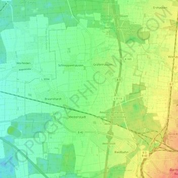
Name: Weiterstadt topographic map, elevation, terrain.
Location: Weiterstadt, Landkreis Darmstadt-Dieburg, Hesse, 64331, Germany (49.88053 8.55019 49.95563 8.63497)
Average elevation: 109 m
Minimum elevation: 87 m
Maximum elevation: 146 m
Thank you for supporting this site ❤️
Make a donation
Make a donation
Gear up for your next adventure:
As an Amazon Associate, this site earns from qualifying purchases at no extra cost to you.
Other topographic maps
Click on a map to view its topography, its elevation and its terrain.
UNESCO Weltnaturerbe Grube Messel
Germany > Hesse > Landkreis Darmstadt-Dieburg > Messel
Average elevation: 171 m