Geolocate

Loomis topographic map

Click on the map to display elevation.

About this map

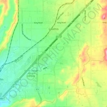
Name: Loomis topographic map, elevation, terrain.

Location: Loomis, Placer County, California, 95650, United States (38.77401 -121.22894 38.83867 -121.17246)

Average elevation: 122 m

Minimum elevation: 64 m

Maximum elevation: 223 m

Other topographic maps

Click on a map to view its topography, its elevation and its terrain.

Foresthill

United States > California > Placer County

Average elevation: 859 m

Devils Peak

United States > California > Placer County

Average elevation: 2,042 m

Lincoln

United States > California > Placer County > Lincoln

Average elevation: 34 m

Gear up for your next adventure:

📡Satellite Messengers - Emergency communication devices
🛌Compact Down Sleeping Bags - Warmth without the bulk, ideal for backcountry camping
🦟Insect Repellent - Protection against insects
🧥Softshell Jackets - Flexible outdoor jackets
📣High-Decibel Survival Whistles - Signaling tool for rescue that carries much further than a human voice

As an Amazon Associate, this site earns from qualifying purchases at no extra cost to you.