Geolocate

Kanab topographic map

Click on the map to display elevation.

About this map
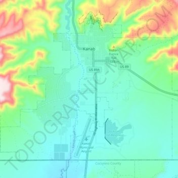
Name: Kanab topographic map, elevation, terrain.

Location: Kanab, Kane County, Utah, United States (37.00068 -112.57594 37.06119 -112.48112)

Average elevation: 1,565 m

Minimum elevation: 1,450 m

Maximum elevation: 1,914 m

Other topographic maps

Click on a map to view its topography, its elevation and its terrain.
Bald Knoll

United States > Utah > Kane County

Average elevation: 2,024 m

Millet Point

United States > Utah > Kane County

Average elevation: 2,107 m

Navajo Lake Lodge

United States > Utah > Kane County

Average elevation: 2,841 m

Duck Creek Village

United States > Utah > Kane County

Average elevation: 2,608 m

Coyote Natural Bridge

United States > Utah > Kane County

Average elevation: 1,361 m

Paria

United States > Utah > Kane County

Average elevation: 1,538 m

Duck Creek Village

United States > Utah > Kane County

Average elevation: 2,608 m

Duck Creek Village

United States > Utah > Kane County

Average elevation: 2,608 m

Rainbow Point

United States > Utah > Kane County

Average elevation: 2,578 m

Gear up for your next adventure:

🔥Windproof Plasma Lighters - USB rechargeable lighters that work in high-altitude winds
🚗Car Camping Gear - Equipment for vehicle camping
📻Handheld UHF Radios - Critical communication for groups in the Australian outback
🌿Flora and Fauna Field Guides - Identify the plants and animals you encounter on your route
🗺️Topographic Maps - Detailed maps for hiking and navigation

As an Amazon Associate, this site earns from qualifying purchases at no extra cost to you.