
Make a donation
Gear up for your next adventure:
As an Amazon Associate, this site earns from qualifying purchases at no extra cost to you.
Lembata Island topographic map
Click on the map to display elevation.
Make a donation
Gear up for your next adventure:
As an Amazon Associate, this site earns from qualifying purchases at no extra cost to you.
Lembata Island
Lembata is an island in the Lesser Sunda Islands, also known as Lomblen island; it is the largest island of the Solor Archipelago, in the Lesser Sunda Islands, Indonesia. It forms a separate regency of the province of Nusa Tenggara Timur. The island has a very irregular coastline with numerous bays and promontories, of which the largest is the Ile Ape peninsula on the island's north coast. The length of the island is about 80 km from the southwest to the northeast and the width is about 30 km from the west to the east. It rises to an elevation of 1,621 metres at Mount Ile Labalekang.
Make a donation
Gear up for your next adventure:
As an Amazon Associate, this site earns from qualifying purchases at no extra cost to you.
About this map
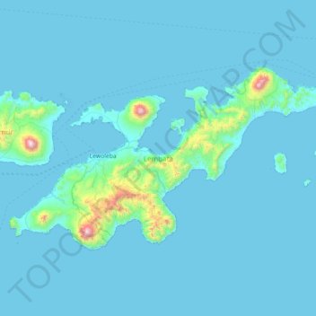
Name: Lembata Island topographic map, elevation, terrain.
Average elevation: 70 m
Minimum elevation: 0 m
Maximum elevation: 1,595 m
Make a donation
Gear up for your next adventure:
As an Amazon Associate, this site earns from qualifying purchases at no extra cost to you.
Other topographic maps
Click on a map to view its topography, its elevation and its terrain.