
Make a donation
Gear up for your next adventure:
As an Amazon Associate, this site earns from qualifying purchases at no extra cost to you.
New Westminster topographic map
Click on the map to display elevation.
Make a donation
Gear up for your next adventure:
As an Amazon Associate, this site earns from qualifying purchases at no extra cost to you.
About this map
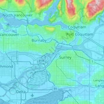
Name: New Westminster topographic map, elevation, terrain.
Average elevation: 87 m
Minimum elevation: -4 m
Maximum elevation: 1,192 m
Make a donation
Gear up for your next adventure:
As an Amazon Associate, this site earns from qualifying purchases at no extra cost to you.
Other topographic maps
Click on a map to view its topography, its elevation and its terrain.
Tsawwassen First Nation
Canada > British Columbia > Metro Vancouver Regional District
Average elevation: 5 m
Coquitlam Watershed
Canada > British Columbia > Metro Vancouver Regional District > Electoral Area A
Average elevation: 673 m
Hillcrest Park
Canada > British Columbia > Metro Vancouver Regional District > Vancouver
Average elevation: 76 m
Make a donation
Gear up for your next adventure:
As an Amazon Associate, this site earns from qualifying purchases at no extra cost to you.
Kitsilano
Canada > British Columbia > Metro Vancouver Regional District > Vancouver
Average elevation: 24 m
West End
Canada > British Columbia > Metro Vancouver Regional District > Vancouver
Average elevation: 15 m
Victoria-Fraserview
Canada > British Columbia > Metro Vancouver Regional District > Vancouver
Average elevation: 72 m
Fairview
Canada > British Columbia > Metro Vancouver Regional District > Vancouver
Average elevation: 32 m
Make a donation
Gear up for your next adventure:
As an Amazon Associate, this site earns from qualifying purchases at no extra cost to you.
Mundy Park
Canada > British Columbia > Metro Vancouver Regional District > Coquitlam
Average elevation: 139 m
Metro Vancouver Regional Parks
Canada > British Columbia > Metro Vancouver Regional District > Electoral Area A
Average elevation: 191 m