
Hanret topographic map
Interactive map
Click on the map to display elevation.
About this map
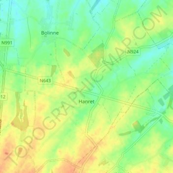
Name: Hanret topographic map, elevation, terrain.
Location: Hanret, Éghezée, Namen, Wallonië, 5310, België (50.56635 4.92039 50.60829 4.98583)
Average elevation: 153 m
Minimum elevation: 136 m
Maximum elevation: 171 m
Other topographic maps
Click on a map to view its topography, its elevation and its terrain.
Aische-en-Refail
België > Namen > Namen > Éghezée
Aische-en-Refail, Éghezée, Namen, Wallonië, 5310, België
Average elevation: 157 m
Noville-sur-Mehaigne
België > Namen > Namen > Éghezée
Noville-sur-Mehaigne, Éghezée, Namen, Wallonië, 5310, België
Average elevation: 148 m
Waret-la-Chaussée
België > Namen > Namen > Éghezée
Waret-la-Chaussée, Éghezée, Namen, Wallonië, 5310, België
Average elevation: 183 m