
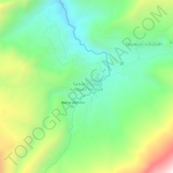
Tarbat n-Tirsal topographic map
Interactive map
Click on the map to display elevation.
About this map
Name: Tarbat n-Tirsal topographic map, elevation, terrain.
Average elevation: 2,239 m
Minimum elevation: 1,863 m
Maximum elevation: 2,970 m
Other topographic maps
Click on a map to view its topography, its elevation and its terrain.
Ait Bou Oulli
Maroc > cercle d'Azilal > Aït Bou Oulli
Ait Bou Oulli, Aït Bou Oulli, caïdat de Tabant, cercle d'Azilal, Province d'Azilal, Béni Mellal-Khénifra, Maroc
Average elevation: 1,853 m
Tagassalt
Maroc > cercle d'Azilal > Aït Bou Oulli
Tagassalt, Aït Bou Oulli, caïdat de Tabant, cercle d'Azilal, Province d'Azilal, Béni Mellal-Khénifra, Maroc
Average elevation: 2,253 m
Jbel Rat
Maroc > cercle d'Azilal > Aït Bou Oulli
Jbel Rat, Aït Bou Oulli, caïdat de Tabant, cercle d'Azilal, Province d'Azilal, Béni Mellal-Khénifra, Maroc
Average elevation: 3,408 m
Jbel Tignousti
Maroc > cercle d'Azilal > Aït Bou Oulli
Jbel Tignousti, Aït Bou Oulli, caïdat de Tabant, cercle d'Azilal, Province d'Azilal, Béni Mellal-Khénifra, Maroc
Average elevation: 3,422 m
Tarhoulit
Maroc > cercle d'Azilal > Aït Bou Oulli
Tarhoulit, Aït Bou Oulli, caïdat de Tabant, cercle d'Azilal, Province d'Azilal, Béni Mellal-Khénifra, Maroc
Average elevation: 1,922 m
n'Ait Larif
Maroc > cercle d'Azilal > Aït Bou Oulli > Taghia
n'Ait Larif, Taghia, Aït Bou Oulli, caïdat de Tabant, cercle d'Azilal, Province d'Azilal, Béni Mellal-Khénifra, Maroc
Average elevation: 1,928 m
Refuge de Tarkeddit
Maroc > cercle d'Azilal > Aït Bou Oulli
Refuge de Tarkeddit, Chemin vers Mgoun, Aït Bou Oulli, caïdat de Tabant, cercle d'Azilal, Province d'Azilal, Béni Mellal-Khénifra, Maroc
Average elevation: 3,059 m