
Make a donation
Gear up for your next adventure:
As an Amazon Associate, this site earns from qualifying purchases at no extra cost to you.
Ackendorf topographic map
Click on the map to display elevation.
Make a donation
Gear up for your next adventure:
As an Amazon Associate, this site earns from qualifying purchases at no extra cost to you.
About this map
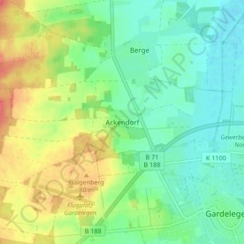
Name: Ackendorf topographic map, elevation, terrain.
Average elevation: 56 m
Minimum elevation: 36 m
Maximum elevation: 89 m
Make a donation
Gear up for your next adventure:
As an Amazon Associate, this site earns from qualifying purchases at no extra cost to you.
Other topographic maps
Click on a map to view its topography, its elevation and its terrain.
Breitenfeld
Deutschland > Sachsen-Anhalt > Altmarkkreis Salzwedel > Gardelegen
Im Jahr 1828 wurde auf einer Anhöhe am Dorf am Weg nach Schwiesau eine Windmühle gebaut. 1896 kam ein festes Gebäude hinzu. Ein Blitzschlag beschädigte die Mühle 1897 schwer. Es folgte eine Instandsetzung. 1949 wurde die unrentabel gewordene Mühle abgerissen.
Average elevation: 88 m
Make a donation
Gear up for your next adventure:
As an Amazon Associate, this site earns from qualifying purchases at no extra cost to you.
Make a donation
Gear up for your next adventure:
As an Amazon Associate, this site earns from qualifying purchases at no extra cost to you.