
Make a donation
Gear up for your next adventure:
As an Amazon Associate, this site earns from qualifying purchases at no extra cost to you.
Grigna topographic map
Click on the map to display elevation.
Make a donation
Gear up for your next adventure:
As an Amazon Associate, this site earns from qualifying purchases at no extra cost to you.
About this map
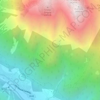
Name: Grigna topographic map, elevation, terrain.
Location: Grigna, Auronzo di Cadore, Belluno, Vénétie, 32041, Italie (46.55888 12.42547 46.57888 12.44547)
Average elevation: 1,507 m
Minimum elevation: 848 m
Maximum elevation: 2,448 m
Make a donation
Gear up for your next adventure:
As an Amazon Associate, this site earns from qualifying purchases at no extra cost to you.
Other topographic maps
Click on a map to view its topography, its elevation and its terrain.
Tre Cime di Lavaredo - Drei Zinnen
Italie > Vénétie > Belluno > Auronzo di Cadore
Les Tre Cime di Lavaredo (littéralement Trois Cimes de Lavaredo) en italien, ou Drei Zinnen en allemand, sont un sommet des Alpes, à 2 999 m d'altitude, dans les Dolomites, à la limite entre les régions italiennes de Vénétie et du Trentin-Haut-Adige/Sud Tirol.
Average elevation: 2,242 m