
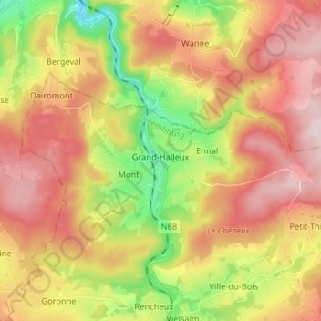
Grand-Halleux topographic map
Interactive map
Click on the map to display elevation.
About this map
Name: Grand-Halleux topographic map, elevation, terrain.
Average elevation: 438 m
Minimum elevation: 258 m
Maximum elevation: 598 m
Other topographic maps
Click on a map to view its topography, its elevation and its terrain.
CRH Domaine de Farnières
België > Luxemburg > Bastenaken > Grand-Halleux > Farnières
CRH Domaine de Farnières, 4, Farnières, Grand-Halleux, Vielsalm, Bastenaken, Luxemburg, Wallonië, 6698, België
Average elevation: 432 m
Farnières
België > Luxemburg > Bastenaken > Grand-Halleux > Farnières
Farnières, Grand-Halleux, Vielsalm, Bastenaken, Luxemburg, Wallonië, 6698, België
Average elevation: 430 m