Geolocate

Luna topographic map

Click on the map to display elevation.

About this map
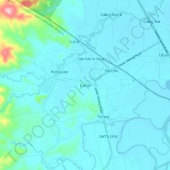
Name: Luna topographic map, elevation, terrain.

Location: Luna, Apayao, Cordillera Administrative Region, 3813, Philippines (18.29121 121.33298 18.37121 121.41298)

Average elevation: 34 m

Minimum elevation: 1 m

Maximum elevation: 328 m

Other topographic maps

Click on a map to view its topography, its elevation and its terrain.

Luna

Philippines > Apayao

Average elevation: 86 m

Conner

Philippines > Apayao

Average elevation: 406 m

Abulug River

Philippines > Apayao

Average elevation: 77 m

Pudtol

Philippines > Apayao

Average elevation: 209 m

Apayao River

Philippines > Apayao

Average elevation: 614 m

Apayao River

Philippines > Apayao

Average elevation: 614 m

Abulug River

Philippines > Apayao

Average elevation: 77 m

Gear up for your next adventure:

📟Satellite Messengers - Two-way satellite communication to stay in touch beyond the cellular grid
🪑Portable Backpacking Chairs - A comfortable seat for studying maps at the end of the day
🎒Dry Bags - Waterproof bags for outdoor gear
🧤Hiking Gloves - Protective gloves for outdoor use
🔪Multitools - Compact tools for outdoor use

As an Amazon Associate, this site earns from qualifying purchases at no extra cost to you.