
Horta topographic map
Interactive map
Click on the map to display elevation.
About this map
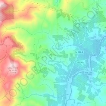
Name: Horta topographic map, elevation, terrain.
Location: Horta, Vila Nova de Foz Coa, Guarda, Douro, Norte, Portugal (41.05115 -7.33260 41.08233 -7.28497)
Average elevation: 532 m
Minimum elevation: 434 m
Maximum elevation: 730 m
Other topographic maps
Click on a map to view its topography, its elevation and its terrain.
U.F Mós, Santo Amaro e Vila Nova Foz Côa
Portugal > Norte > Vila Nova de Foz Coa
U.F Mós, Santo Amaro e Vila Nova Foz Côa, Vila Nova de Foz Coa, Guarda, Douro, Norte, Portugal
Average elevation: 385 m
Numão
Portugal > Norte > Vila Nova de Foz Coa
Numão, Vila Nova de Foz Coa, Guarda, Douro, Norte, Portugal
Average elevation: 447 m