
Comandante Noel topographic map
Interactive map
Click on the map to display elevation.
About this map
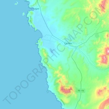
Name: Comandante Noel topographic map, elevation, terrain.
Location: Comandante Noel, Provincia de Casma, Áncash, Perú (-9.68243 -78.43373 -9.33606 -78.29146)
Average elevation: 152 m
Minimum elevation: -1 m
Maximum elevation: 1,361 m
Other topographic maps
Click on a map to view its topography, its elevation and its terrain.
El Huaro
Perú > Áncash > Comandante Noel
El Huaro, Comandante Noel, Casma, Áncash, Perú
Average elevation: 12 m
Tortugas
Perú > Áncash > Comandante Noel
Tortugas, Comandante Noel, Casma, Áncash, Perú
Average elevation: 70 m