
Make a donation
Gear up for your next adventure:
As an Amazon Associate, this site earns from qualifying purchases at no extra cost to you.
Darby topographic map
Click on the map to display elevation.
Make a donation
Gear up for your next adventure:
As an Amazon Associate, this site earns from qualifying purchases at no extra cost to you.
About this map
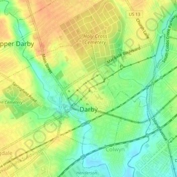
Name: Darby topographic map, elevation, terrain.
Location: Darby, Delaware County, Pennsylvania, 19023, United States (39.91252 -75.27531 39.93057 -75.24698)
Average elevation: 22 m
Minimum elevation: 2 m
Maximum elevation: 40 m
Make a donation
Gear up for your next adventure:
As an Amazon Associate, this site earns from qualifying purchases at no extra cost to you.
Other topographic maps
Click on a map to view its topography, its elevation and its terrain.
Pendle Hill
United States > Pennsylvania > Delaware County > Nether Providence Township
Average elevation: 61 m
Chadds Ford Township
United States > Pennsylvania > Delaware County > Chadds Ford Township
Average elevation: 101 m
Make a donation
Gear up for your next adventure:
As an Amazon Associate, this site earns from qualifying purchases at no extra cost to you.
Villanova
United States > Pennsylvania > Delaware County > Radnor Township > Radnor
Average elevation: 119 m
Newtown Square
United States > Pennsylvania > Delaware County > Newtown Township > Springton Pointe Woods
Average elevation: 118 m
Upper Providence
United States > Pennsylvania > Delaware County > Upper Providence Township
Average elevation: 99 m
Booths Corner
United States > Pennsylvania > Delaware County > Bethel Township
Average elevation: 105 m
Make a donation
Gear up for your next adventure:
As an Amazon Associate, this site earns from qualifying purchases at no extra cost to you.
Ithan
United States > Pennsylvania > Delaware County > Radnor Township > Saint Davids
Average elevation: 116 m
Make a donation
Gear up for your next adventure:
As an Amazon Associate, this site earns from qualifying purchases at no extra cost to you.
Garrett Hill
United States > Pennsylvania > Delaware County > Radnor Township > Radnor
Average elevation: 117 m
Make a donation
Gear up for your next adventure:
As an Amazon Associate, this site earns from qualifying purchases at no extra cost to you.
Villanova
United States > Pennsylvania > Delaware County > Radnor Township > Radnor
Average elevation: 119 m
Moylan-Rose Valley Station
United States > Pennsylvania > Delaware County > Nether Providence Township
Average elevation: 65 m
Make a donation
Gear up for your next adventure:
As an Amazon Associate, this site earns from qualifying purchases at no extra cost to you.
Villanova
United States > Pennsylvania > Delaware County > Radnor Township > Radnor
Average elevation: 119 m
Chadds Ford
United States > Pennsylvania > Delaware County > Chadds Ford Township
Average elevation: 86 m
Booths Corner
United States > Pennsylvania > Delaware County > Bethel Township
Average elevation: 105 m
Make a donation
Gear up for your next adventure:
As an Amazon Associate, this site earns from qualifying purchases at no extra cost to you.
Lapidea
United States > Pennsylvania > Delaware County > Nether Providence Township
Average elevation: 31 m
Wallingford
United States > Pennsylvania > Delaware County > Nether Providence Township
Average elevation: 41 m
Broomall
United States > Pennsylvania > Delaware County > Marple Township > Broomall
Average elevation: 94 m
Make a donation
Gear up for your next adventure:
As an Amazon Associate, this site earns from qualifying purchases at no extra cost to you.
West Ridley Park
United States > Pennsylvania > Delaware County > Ridley Township
Average elevation: 21 m
Newtown Square
United States > Pennsylvania > Delaware County > Newtown Township > Springton Pointe Woods
Average elevation: 118 m
Make a donation
Gear up for your next adventure:
As an Amazon Associate, this site earns from qualifying purchases at no extra cost to you.
Ardmore Park
United States > Pennsylvania > Delaware County > Haverford Township
Average elevation: 95 m
Kirklyn
United States > Pennsylvania > Delaware County > Upper Darby > Kirklyn
Average elevation: 70 m
Saint Davids
United States > Pennsylvania > Delaware County > Radnor Township
Average elevation: 122 m
Make a donation
Gear up for your next adventure:
As an Amazon Associate, this site earns from qualifying purchases at no extra cost to you.
Ward
United States > Pennsylvania > Delaware County > Concord Township > Ward
Average elevation: 104 m