
Make a donation
Gear up for your next adventure:
As an Amazon Associate, this site earns from qualifying purchases at no extra cost to you.
Lüdenscheid topographic map
Click on the map to display elevation.
Make a donation
Gear up for your next adventure:
As an Amazon Associate, this site earns from qualifying purchases at no extra cost to you.
Lüdenscheid
Lüdenscheid is located on the saddle of the watershed between the Lenne and Volme rivers which both empty into the Ruhr river (which subsequently flows into the Rhine), with three smaller valleys leading to them. The saddle has a height of 420 meters, higher elevations on the watershed are an unnamed hilltop of 505 meters in the north, and the 663 meters high Nordhelle in the Ebbe Mountains range. In the surrounding mountainous area, six dams created reservoirs to regulate the water flow in the Ruhr river and supply drinking water. The mountainous nature of the city's territory gave rise to the nickname "Bergstadt" (mountain town). The original settlement circles around the church built on a ledge of the slope above the saddle.
Make a donation
Gear up for your next adventure:
As an Amazon Associate, this site earns from qualifying purchases at no extra cost to you.
About this map
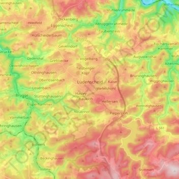
Name: Lüdenscheid topographic map, elevation, terrain.
Location: Lüdenscheid, Märkischer Kreis, North Rhine-Westphalia, Germany (51.15512 7.55221 51.27076 7.72326)
Average elevation: 384 m
Minimum elevation: 161 m
Maximum elevation: 587 m
Make a donation
Gear up for your next adventure:
As an Amazon Associate, this site earns from qualifying purchases at no extra cost to you.