
Make a donation
Gear up for your next adventure:
As an Amazon Associate, this site earns from qualifying purchases at no extra cost to you.
Corona topographic map
Click on the map to display elevation.
Make a donation
Gear up for your next adventure:
As an Amazon Associate, this site earns from qualifying purchases at no extra cost to you.
About this map
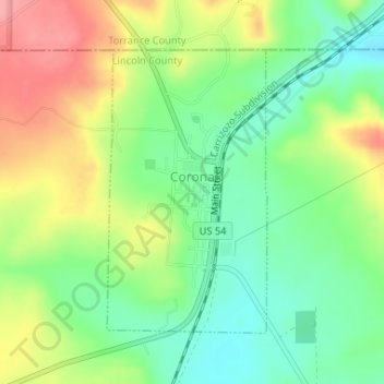
Name: Corona topographic map, elevation, terrain.
Location: Corona, Lincoln County, New Mexico, United States (34.24007 -105.60401 34.25999 -105.59037)
Average elevation: 2,055 m
Minimum elevation: 2,011 m
Maximum elevation: 2,115 m
Make a donation
Gear up for your next adventure:
As an Amazon Associate, this site earns from qualifying purchases at no extra cost to you.
Other topographic maps
Click on a map to view its topography, its elevation and its terrain.
Ruidoso Downs
United States > New Mexico > Lincoln County > Ruidoso Downs
Ruidoso Downs is located in southern Lincoln County at 33°19′54″N 105°35′46″W / 33.33167°N 105.59611°W / 33.33167; -105.59611 (33.331690, -105.596079). It is bordered to the west by Ruidoso. Elevation is 6,420 feet (1,960 m).
Average elevation: 2,091 m
Make a donation
Gear up for your next adventure:
As an Amazon Associate, this site earns from qualifying purchases at no extra cost to you.