Geolocate

Farmington topographic map

Click on the map to display elevation.

About this map
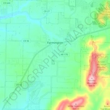
Name: Farmington topographic map, elevation, terrain.

Location: Farmington, Washington County, Arkansas, 72730, United States (35.99986 -94.28503 36.06862 -94.22387)

Average elevation: 393 m

Minimum elevation: 335 m

Maximum elevation: 567 m

Other topographic maps

Click on a map to view its topography, its elevation and its terrain.

Canehill

United States > Arkansas > Washington County

Average elevation: 446 m

Durham

United States > Arkansas > Washington County

Average elevation: 411 m

Sonora

United States > Arkansas > Washington County

Average elevation: 388 m

Pinnacle

United States > Arkansas > Washington County

Average elevation: 360 m

Wyman

United States > Arkansas > Washington County

Average elevation: 377 m

Savoy

United States > Arkansas > Washington County

Average elevation: 348 m

Sunset

United States > Arkansas > Washington County

Average elevation: 628 m

Brentwood

United States > Arkansas > Washington County

Average elevation: 513 m

Evansville

United States > Arkansas > Washington County

Average elevation: 376 m

Strickler

United States > Arkansas > Washington County

Average elevation: 486 m

Hogeye

United States > Arkansas > Washington County

Average elevation: 414 m

Gear up for your next adventure:

🔦Headlamps - Hands-free lighting for hiking
👟Lightweight Trail Runners - Agile footwear for fast movement over rugged Australian terrain
👣Snake & Scrub Gaiters - Protection against spinifex, mud, and snakes while walking off-track
🧦Merino Wool Hiking Socks - Moisture-wicking socks to prevent blisters during long topographic surveys
🦟Heavy Duty Insect Repellent - Essential protection against flies, mozzies, and march flies

As an Amazon Associate, this site earns from qualifying purchases at no extra cost to you.