
Thank you for supporting this site ❤️
Make a donation
Make a donation
Gear up for your next adventure:
As an Amazon Associate, this site earns from qualifying purchases at no extra cost to you.
Altamont topographic map
Click on the map to display elevation.
Thank you for supporting this site ❤️
Make a donation
Make a donation
Gear up for your next adventure:
As an Amazon Associate, this site earns from qualifying purchases at no extra cost to you.
About this map
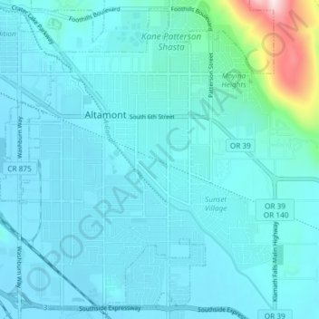
Name: Altamont topographic map, elevation, terrain.
Location: Altamont, Klamath County, Oregon, 97603, United States (42.17328 -121.75714 42.22499 -121.68340)
Average elevation: 1,285 m
Minimum elevation: 1,243 m
Maximum elevation: 1,646 m
Thank you for supporting this site ❤️
Make a donation
Make a donation
Gear up for your next adventure:
As an Amazon Associate, this site earns from qualifying purchases at no extra cost to you.