
Make a donation
Gear up for your next adventure:
As an Amazon Associate, this site earns from qualifying purchases at no extra cost to you.
Red Bank topographic map
Click on the map to display elevation.
Make a donation
Gear up for your next adventure:
As an Amazon Associate, this site earns from qualifying purchases at no extra cost to you.
About this map
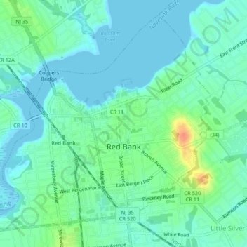
Name: Red Bank topographic map, elevation, terrain.
Location: Red Bank, Monmouth County, New Jersey, United States (40.33625 -74.09063 40.36369 -74.04985)
Average elevation: 11 m
Minimum elevation: -2 m
Maximum elevation: 45 m
Make a donation
Gear up for your next adventure:
As an Amazon Associate, this site earns from qualifying purchases at no extra cost to you.
Other topographic maps
Click on a map to view its topography, its elevation and its terrain.
Clarks Mills
United States > New Jersey > Monmouth County > Manalapan Township
Average elevation: 26 m
Bradley Park
United States > New Jersey > Monmouth County > Neptune > Bradley Park
Average elevation: 7 m
Make a donation
Gear up for your next adventure:
As an Amazon Associate, this site earns from qualifying purchases at no extra cost to you.