
Thank you for supporting this site ❤️
Make a donation
Make a donation
Gear up for your next adventure:
As an Amazon Associate, this site earns from qualifying purchases at no extra cost to you.
Tronzano topographic map
Click on the map to display elevation.
Thank you for supporting this site ❤️
Make a donation
Make a donation
Gear up for your next adventure:
As an Amazon Associate, this site earns from qualifying purchases at no extra cost to you.
About this map
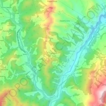
Name: Tronzano topographic map, elevation, terrain.
Location: Tronzano, Mozzano, Ascoli Piceno, Marche, 63093, Italy (42.81892 13.48607 42.85892 13.52607)
Average elevation: 324 m
Minimum elevation: 141 m
Maximum elevation: 652 m
Thank you for supporting this site ❤️
Make a donation
Make a donation
Gear up for your next adventure:
As an Amazon Associate, this site earns from qualifying purchases at no extra cost to you.