
Make a donation
Gear up for your next adventure:
As an Amazon Associate, this site earns from qualifying purchases at no extra cost to you.
Farndale topographic map
Click on the map to display elevation.
Make a donation
Gear up for your next adventure:
As an Amazon Associate, this site earns from qualifying purchases at no extra cost to you.
Farndale
With the population having decreased greatly from the 668 that is recorded in "A Topographical Dictionary of Yorkshire" by Thomas Lansdale published in 1822 when farndale East side had a population of 455 and Farndale West Side had a Population of 213.
Make a donation
Gear up for your next adventure:
As an Amazon Associate, this site earns from qualifying purchases at no extra cost to you.
About this map
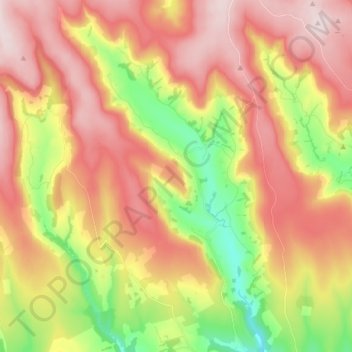
Name: Farndale topographic map, elevation, terrain.
Average elevation: 273 m
Minimum elevation: 86 m
Maximum elevation: 431 m
Make a donation
Gear up for your next adventure:
As an Amazon Associate, this site earns from qualifying purchases at no extra cost to you.