
Canbelego topographic map
Interactive map
Click on the map to display elevation.
About this map
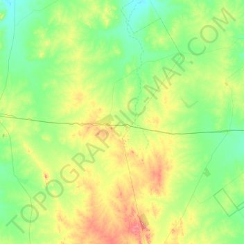
Name: Canbelego topographic map, elevation, terrain.
Average elevation: 255 m
Minimum elevation: 186 m
Maximum elevation: 453 m
Other topographic maps
Click on a map to view its topography, its elevation and its terrain.
Cobar
Australia > New South Wales > Cobar Shire Council
Cobar, Cobar Shire Council, New South Wales, 2835, Australia
Average elevation: 229 m
Nymagee
Australia > New South Wales > Cobar Shire Council
Nymagee, Cobar Shire Council, New South Wales, 2831, Australia
Average elevation: 294 m
Euabalong West
Australia > New South Wales > Cobar Shire Council
Euabalong West, Cobar Shire Council, New South Wales, 2877, Australia
Average elevation: 164 m