Geolocate

Diguisit topographic map

Click on the map to display elevation.

About this map

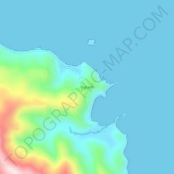
Name: Diguisit topographic map, elevation, terrain.

Location: Diguisit, Baler, Aurora, Central Luzon, Philippines (15.72818 121.61087 15.76818 121.65087)

Average elevation: 68 m

Minimum elevation: 0 m

Maximum elevation: 448 m

Other topographic maps

Click on a map to view its topography, its elevation and its terrain.

Dicasalarin Cove

Philippines > Aurora > Baler

Average elevation: 77 m

Aguang River

Philippines > Aurora > Baler

Average elevation: 36 m

Quezon Memorial Park

Philippines > Aurora > Baler > Sabang

Average elevation: 6 m

Gear up for your next adventure:

🎨Portable Watercolor Kits - Paint the landscapes and topographic views you discover
🕯️Emergency Whistles - Safety whistles for hiking
🎒3L Hydration Reservoirs - Hands-free drinking to stay hydrated on steep contour climbs
🎒Tactical Waist Packs - Quick access to your compass, phone, and snacks while walking
🧊Insulated Cooler Bags - Keep food fresh for day trips to remote geographic sites

As an Amazon Associate, this site earns from qualifying purchases at no extra cost to you.