
Over topographic map
Click on the map to display elevation.
About this map
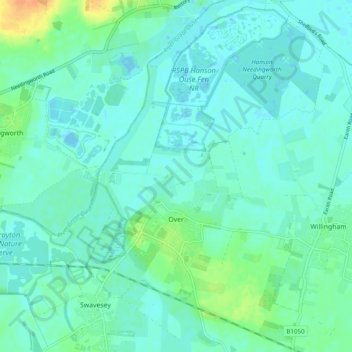
Name: Over topographic map, elevation, terrain.
Average elevation: 7 m
Minimum elevation: -3 m
Maximum elevation: 31 m
Other topographic maps
Click on a map to view its topography, its elevation and its terrain.
Chittering
United Kingdom > England > Cambridgeshire > South Cambridgeshire > Waterbeach
Average elevation: 3 m
Odsey
United Kingdom > England > Cambridgeshire > South Cambridgeshire > Steeple Morden
Average elevation: 82 m
Great Chishill
United Kingdom > England > Cambridgeshire > South Cambridgeshire
Average elevation: 112 m
Nine Wells
United Kingdom > England > Cambridgeshire > South Cambridgeshire > Great Shelford
Average elevation: 20 m
Bourn Bridge
United Kingdom > England > Cambridgeshire > South Cambridgeshire > Little Abington
Average elevation: 39 m
Little Linton
United Kingdom > England > Cambridgeshire > South Cambridgeshire > Linton
Average elevation: 62 m
Hatley's Children's Pit
United Kingdom > England > Cambridgeshire > South Cambridgeshire > Landbeach
Average elevation: 7 m
Westwick
United Kingdom > England > Cambridgeshire > South Cambridgeshire > Oakington > Westwick
Average elevation: 11 m
Gamlingay Wood NR
United Kingdom > England > Cambridgeshire > South Cambridgeshire > Gamlingay
Average elevation: 56 m
Hayley Wood NR
United Kingdom > England > Cambridgeshire > South Cambridgeshire > Hatley
Average elevation: 76 m