Geolocate

Caral topographic map

Click on the map to display elevation.

About this map

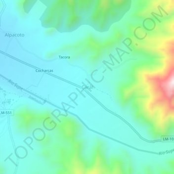
Name: Caral topographic map, elevation, terrain.

Location: Caral, Supe, Province of Barranca, Lima, Peru (-10.91007 -77.52108 -10.87007 -77.48108)

Average elevation: 467 m

Minimum elevation: 325 m

Maximum elevation: 1,000 m

Other topographic maps

Click on a map to view its topography, its elevation and its terrain.

Sacred City of Caral-Supe

Peru > Lima > Supe > Caral

Average elevation: 393 m

playa

Peru > Lima > Supe

Average elevation: 17 m

Gear up for your next adventure:

🧥Down Jackets - Insulated jackets for cold weather
🎒40L Day Hiking Backpacks - Comfortable packs with hydration support for long days exploring topographic peaks
🧴SPF 50+ Bulk Sunscreen - Maximum protection for long-term outdoor exposure
🧢Outdoor Sun Hats - Sun protection hats for hiking
🆘Personal Locator Beacons (PLB) - Satellite emergency beacons for life-saving help in areas with no mobile coverage

As an Amazon Associate, this site earns from qualifying purchases at no extra cost to you.